 Live Music Archive
 Librivox Free Audio
 Metropolitan Museum
 Cleveland Museum of Art
 Internet Arcade
 Console Living Room
 Books to Borrow
 Open Library
 TV News
 Understanding 9/11
tv News 4 Midday NBC September 30, 2010 11:00am-12:00pm EDT
11:00 am

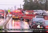
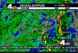
the pounding rai started well before sun up today. so did the concern about flooding across the area. once daylight hit, rain waters began covering our roadways and the morning commute was immediately impacted. the weather problems do not end there, however. the rain is expecd to continue for hours. good morning and welcome to news 4 midday. i'm barbara harrison. it's thursday, september 30th, 2010. the question now, how much me rain the weather system has caused tornado warnings and watches throughout our area. the rain here in the district has been heavy at times and continues to be steady at this hour. tom kierein begins the team coverage. it started about 3:00 this morning. the rain came in heavy waves and since them in some locations in southern maryland there's been over seven inches that has fallen there. they have floodin problems in st. mary's counts andcal ver
11:01 am
county, anne arundel county. we ve a severe thunderstorm warning issued for the district of columbia as well as montgomery, northern prince george's county and howard count y all coming from this particular storm cell that is now in northwest and northeast washington advancing to the north. this one may be producing some damaging winds as well as into prince george's county near college park and near the beltway where it crosses into silver spring. they're getting some heavy downpours. there may be damaging winds there and on up to ashton and perhaps near olney. this is just east of wheaton and aspen hill. that heavy downpour storm is perhaps producing some damaging wds, strong gusts. it's a severe thunderstorm warning meaning we may have damaging winds for northeast and nor northwest washington and then into maryland right from near hyattsville to silver spring and
11:02 am
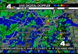
college park, then further to the north to eastern and southeastern montgomery county. heavy rain, damaging winds as well fromvil villsilver spring. elsewhere, heavy pockets of heavier rain further to the south now in charles countynd king george in the northern neck of virginia as well as in southern maryland and coming out of the northern neck of virginia. now some of the rainfa totals around the region have already been over three inches. we could have up to as many as 7 inches by the time this all ends. we've seen that in southern maryland, all these cnties in red have had flooding this morning and we have that flood warning continuing into this afrnoon, all those counties in red. look at the rainfall totals we've had three to four inches in our western to northern suburbs, over 2 1/2 inches in washington. look at southernmaryland. 7 1/2 inches. annapolis has had 6.7 inches of rain and this total amount is
11:03 am
only going to increase. we have a tornado watch in effect. veronica johnson joins me from storm center 4 with the latest on that. >> indeed, a lot of circulation in the atmosphere and with that circulation the possibility of not only severe thunderstorm warnings in effect right now but those tornado warnings like we saw earlier today. not just here but if you have plans of traveling southbound around richmond, southeastern virginia around norfolk or east of raleigh, rth carolina through the wilmington area, that until 1:00 p. and it's areas around frederick county down through the district on south and off to the east. a lot of folks say, well, what do i do when i'm under a tornado warning? if you're at home, you want to get to a basement if possible, away from any windows and doors and away from the west and southwest walls. that's where we find a tremendous amount of wind with these systems moving from typically southwest to
11:04 am

northeast. unr anything srdy if you can and away from any flying devertebrae. t debris. if you live in a high rise, what's the safest place? you do not want to be in an elevator. interior rooms and halls are best. there's a look at some of the rainfall. you folks in fredericburg, virginia, getting over 2 inches of rain. that's just today. over 3 1/2 for this storm alone. look at fairfax, virginia. 3.9 inches, the total storm amount. st. mary's city, a lot of rain in a very short period of time, close to 9 inches there. you can see why we have some road closures ound the area. mclaen, virginia, vienna, high water covering one of the bridge areathere. anne arundel, route 450 closed to high water at hunt wood drive and virginia avenue northwest between 21st a 25th street. tom, back to you. >> thanks so much, veronica. again, a severe thunderstorm warning in effect for the
11:05 am

district of columbia, montgomery, prince george's, north of prince george's county and central howard county for about another 15 minutes. stay tune. i'll have another update and veronica will joy me again. >> thanks very much. due to the weather conditions all st. mary's county public schools will dismiss two hours earltoday. all afternoon and evenig activities have been canceled in st. mary's county. no addition al -- or ino additional amounts are made, schools will operate on a normal schedule tomorrow. due to weather conditions, all public county schools will dismiss two hours ely today. our team coverage of this wet day continues now with tracee wilkins who joins us from annandale, virginia. that's where this morning's floods took a dangerous turn. >> reporter: here in northern have virginia as we s throughout the rest of the area a big mess with plenty of roadslosed throughout the area. and here on this road another example why you should not try
11:06 am
your hand at high water. it was a wet, long, miserable morning commute that started for a lot of drivers on thinner loop of the beltway after a tractor-trailer jackknifed. it happened just before 5:00 a.m. fuel poured from the truck causing major backups throughout theorning commute. meanile, in annaale and wood burn road a vdot worker says a husband and wife drove through the roadblock and tried to t through this standing water but didn't make it. they both had to be rescued. the water stood as high as two feet on the far side and was about at a foot and a half on e sides t driver tried to go through. >> and i work right off wood burn road so i'm worried about what sections are cut off right now. so i haven't been down there. i'm wondering what it's like. >> reporter: as crews surveyed flood-prone areas for the possibility of road closures, water ran through a local annandale park and threatened nearby prosperity avenue. >> a lot of accidents, a lot of
11:07 am

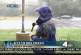
traffic. definitely heavier. >> took me longer, about 40 minutes and i live 15 minutes from school. >> reporter: there were road closures throughou northern virginia. today we must go on. >> but nothing stops me from getting my could have tea. there i am right there. i'm happy. >> reporter: and what we saw throughout northern havevirgini areas flooding and getting high water in places th are used to getting high water when we get substantial rain so at is a remind reminder to drivers this afternoon be careful as you go through these areas. most folks who live among these areas kn where they are. these are the places you're going to want to avoid. it could be a while before the water starts to recede n. nandale, i'm tracee wilkins, news 4. two metro buses crashed this morning with 40 people in all onboard. it happened at the intersection of university boulevard and burden of proof net avenue in silver spring. nearly two dozen people were taken to the hospital.
11:08 am

megan mcgrath has the latest. >>eporter: some of the injured were wheeled away wearing nec braces. others were looked for on the scene and went on their way. 23 people were hurt when two metro buses collided on uversity boulevard near four corners this morning. >> all of them were nonlife threatening, most of which were orthopedic-type injuries, neck pain, back pn, some minor lacerations and abrasions. some more serious injuries were injuries complaining of internal pai >> reporter: the accident happened just down the street from blair high school. there were ten blair students aboard, eight were taken to the hospital. >> it's hard to say. it looked like it was bumps and bruises. as you can see from the scene, anything is possible based on that looked like the buses rear-ended each other. the remaining students ended up going to school. they were checked ou. it seems like everything was fine with them. they did walk. >> reporter: eastbound university boulevard was shut
11:09 am
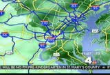
down causing a big backup during rush hour. cars at the front near the accident were unableo turn around because of the median strip, so they sat and sat. how long have you been sitting here? >> about an hour. yeah, i wouldsay. my son is going to school and not getting there on time certainly. that was megan mcgrath reporting. the roads have been a mess all morning long. now the latest on what it's like out there right now. jerry, good morning. good morning, everyone as we take a live look on the beltway, in greenbelt the inner and outer loop traffic moving along pretty well. speeds are down as they should be traveling between i-95 and the wilson bridge. let me update you quickly. a list of a couple of additional road closures. in addition to the road closures announced earlier on450 announced word that central avenue west of route 2 is now closed and we have problems on route 50 just off the bay bridge. high water affecting traffic in both directions so be forewarned
11:10 am

of that. over to northern virginia we go. take a look. not bad at all looking good finally along interstate 66. some of the secondary roadways as tracy mentioned earlier, now closed between spring hill road, east of spring hill road, old courthouse and bueller road remains closed. west felled boulevard at wal y road now closed due to flooding. montgomery county just getting the word that thers a stretch of carroll avenue just closed off because of flooding conditions over near the hospital in tacoma park. so detours are now being set up for tha we are farrom being out of the woods. barbara, back to you. >> all right, jerry, we'll continue to watch closely and talk to you soon. right now more people are without power. dominion reports nearly 4,000 people without power in northern virginia. b dw&e reporting 2,400 without power. pepco reports 400 are without electrity and montgomery county, prince george's county and the disict. and here's a look at what the
11:11 am
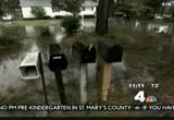
syem has already donnels where. the remains of tropical storm nicole dumped heavy rain in southeast north carolina. the rain is puing a strain on area rivers and streams already overflowing. some roads are impassable because of that deep water. the steady rain caused flooding along the carolina coast overnight as well. here's a look at myrtle beach. so far there has not been any serious reports of flooding on the beach but parts of north carolina are under a state of emergency. we're joined now on the phone by karen everett in st. mary's county. karen, what can you tell us about how it's looking there now? >> reporter: good morning. s citizens are still being subjected to a lot of rain, flash flood warning has been extended through the afternoon and flash flood watch remaining in effect. >> and what are you seeing outside right now? is it really coming down at this moment? >> that's a fair assessment. it is really coming down. we only have two road closures
11:12 am
and state highway administration ancounty roads are on it. there's one on route 5 and one 244. other than that the tornado warning has been lifted. >> now tell us about schools closing today. >> from what i understand a few bus drivers had to use alternate routes and the pre-k program children are going to remain where they are until the final closing because of the weather. >> and afternoon activities on schedule for this evening in st. mary's county? >> they have all been canceled, school, recreation and parks. >> so you have a lot of water to deal with out there. any of those waterways reached their banks already in st. mary's county? >> i'm sorry, i missed that. >> have you had any flooding there in the county that you're having to deal with at this
11:13 am
time? >> yes, two road closures due to flooding. >> i see. so what is the plan to prepare for the rest of this dayn rms of flooding? >> well, we are continuing to monitor the situation very closely and letting our citizens know. our local radio station and websites are getting the word out to our citizens. emergency information hotlines to let them know about road closures. >> all right. we thank you so much, karen everett in st. mary's county for bringing us up to speed on what's going on there and happy to hear that the tornado watch or warning is over there thousand in your coun. >> yes. we're happy about that, too, and thank you for helping to let our citizens know. >> thank you so much. let's go to tom kierein. >> many have had up to eight inches of rain this morning. an incredible amount of rain and it's not done there yet even though the rain has at that pointered off in st. mary's county there is still another batch about to move in. we have a severe thunderstorm
11:14 am

warning that may be expiring now but it is still a very strong storm that is moving through southeastern montgomery county now. this one may have some strong gusts owind that may be producing damaging winds causing some trees to topple over and bring down power lines from just to the north of aspen hill and then along new mpshire avenue up toward sunshine where it meets georgia avenue as well as near briton dam on the howard county line. they're getting very heavy rain right now and this storm may be producing damaging winds as it passes off to the north and i n show you some of the communities affected by this particular storm over the next w minutes as it does ve int howard county. these are the locations that could have the storm moving through, sykesville, perhaps by 11:20 or so and then up to mt. airby 11:22, to liberty manor and liberty reservoir area could have some of had a heavy rain
11:15 am

maybe with some damaging winds mong up that way. but right now that storm is just right on the howard cnty and montgomery county line north of ashton up to the briton dam and near the reservoir. that's where they're getting tremendous amounts of rain right now and it continues to track off to the north and east and the wider view of the radar is showing generally other areas that the rain is beginning to brea up a little bit. we still have a few pockets of heavier rain to our south. we'll have a complete report coming up in a few minutes and frequent updates over the next hour. back to you, barbara. >> all right, thank you very much, tom. we'll be back to you shortly. our time now is 11:15. a terror arrest in pakistan. coming up how the man is connected with the failed times square bombing in new york city. plus, oscar nominated actor tony curtis has died. we'll look ba at his life and career. and we'll continue our coverage of today's severe weather, the rain and the risk of


11:18 am

we have brking news rght now. we have learned the cleveland park metro station has been closed because of a suspicious package there at the station. police are on e scene. that's at the cleveland park metro station. an investigation of a suspicious package there and we will bring you more as it comes in to us. now we're going to have more on our weather coming up, too. the national transportation safety board is investigating a charter bus accident that killed the driver and sent seral
11:19 am

children a adults to the hospital yesterday. the group finished touring washington, d.c., when that bus they were on plund off a flyover ramp and on to the highway below. it happened yesterday afternoon in the middle of rush hour on i- i-270 northbound in ntgomery county. we are joined live from the newsroom with the latest on this crash and what they've learned so far. elaine, good morning. >> reporter: good morning to you, barbara. t ntsb launched a go team to investigate the accident. meantime, records for the bus mpany shows it has a satisfactory safety rating. i-270 northbound was closed for five hours yesterday after a charter fell off of a flver r ramp. its driver was killed and at least a dozen people were hurt. the passengers include several children and their parents. emergency crews treated many of them on the side of the highway. the group was from carlyle, pennsylvania, heading home after a tour of wshington, d.c.
11:20 am

about a dozen of them went to various hospitals with injuries, eight were treated at suburban hospital bethesda. >> we activated other trauma team. we have extra nursing here. we pooled our resources to appropriately care for a major trauma situation. >> actually the thing that stands out about this accident is the fall seems pretty significant. the mechanism, the tiziphysics behind it, i'm surised there weren't more is severe injuries. >> reporter: drivers from two other cars were injured as a result of the accident. the bus driver has been identified as 66-year-old joseph clabaugh of hanover. he may have been suffering from some type of medical problem. an autopsy will have to determine if he died as aesult of the accident or whatever led
11:21 am

to that accident. back to you. we ve new information today about the attempted times square bombing. police in pakistan have arrest add man for allegedly playing an important role in assisting faisal shahzad. they arrested the man with shahzad throughout his time in pakist pastan. he works for the council and accompanied shahzad to meet militant leaders. pakistan has already charged three other men with assisting shahzad and sending him money. meanwhile, government officials released video of a test showing the power of that car bomb faisal shahzad put together and had itone off this is what it would have looked like. shahzad says he thought he would kill about 40 people. he pled guilty to all ten counts against him in june and court documents say he was planning to strike multiple times. they say he studied new york city web cams to oerve foot
11:22 am

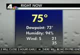
traffic around the area. those web cams revealed a lot to him, they say. he also said that he wanted to, quote, join his brothers in jihad. and we continue to follow the storms hitting us right now. we have the ra still coming down. tom is here it to tell us more about what we can expect. >> this is amazing. i came on the air at 4:15 this morning, seven hours ago, and it has been raining ever since then. many creeks and streams out of their banks, multip road closures, gh water most locations. many basements have water as well and more rain is on the way. let's take a look now at the live view fr our sky watcher camera and it is covered with rain now and the visibility is very low. right now 75 and the dew point is up there. it's a tropical feeling right now and, in fact, we are being affected by that remnant. this is part of that and we've had winds out o the south around 20 miles an hour.
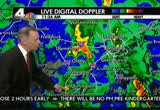
11:23 am
ju had a gust at reagan national at 35. so that is when that thunderstorm came through there and ts is going to continue off and on for the next several hours as we look at the radar over the last three hours we've had the heaviest rains in southern maryland righ along the western shore of the bay but we have had a few areas of some very heavy rain coming through wa washington. justad that one cell came right through northeast and southeast washington. that is rapidly advancing off to thnorth, through howard county, montgomery county and the local view of radar showing that is the heaviest downpour right now occurring on radar. right now it's into wesrn howard county, very heavy downpours associated with that. maybe some damaging winds a well. it's rapidly advancing to t north and pulling out of montgomery county. to near laytonsvile ov to briton dam, etchison, that area getting very heavy rain now and continuing to advance to the north. getting some other heavy downpours as well.
11:24 am
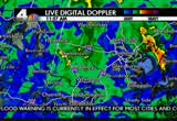
we're not quite done here. here in annandale and in arlington that is continuing to show the radar there, that area of yellow and orange of a pocket of heavy rain. also some other heavier rain near mt. vernon and south of alexandria. elsewhere the rain is beginning to break up off to our west, some pockets of moderate rain there now. on the radar over the last three hours this overall trendis showing that it's finally beginning to weaken ju a little bit and we do have all these counties in red, though, experiencing flooding right now. we have flood warnings in effe. it will be until 4:30 this afternoon d an additional couple of inches of rain. already we've had rainfall totals in st. mary's county up to 8 and 9 inches and up to 6 to 7 inches in anne arundel county. off to our west three or four inches falling there a with more to come at national airport since yesterday almost 3 inches have fallen. veronica johnson joins me with
11:25 am

the latest. veronica? not only is this a situation we have a tremendous amount of rain coming through the area, tropical rain, but we also still have a l of spip in the atmosphere. and because of that we've got the possibility of tornadoes. until 1:00today national weather service has issued a tornado watch that goes in areas all the way from carroll county south down through stafford, caroline county and off to the east and that really goes even further on down to portions of eastern north carolina, raleigh, areas off to the east. so what do you do when we're under a tornado warning? get to the basement if possible, away from the west and southwest walls. get under something sturdy and, of course, even if you're in a high rise make sure you stay away from any windows. no matter how small because glass can fly quite easily with high winds coming through. and here are just some of the road closures through the area. virginia avenue, the latest, 21st street and 25th at virginia avenue northwest. winds could gust up to 25 miles
11:26 am

per hour right into tomorrow morning. tom? is. >> thanks so much, veronica. i appreciate that and we'll have this rain tapering off and ending by later tonight and tomorrow into the weekend will be drying out. barbara? >> thank you very much, tom. let's go to pete about a road rescue. >> how are you >> tell us what's happening out there? >> well, we had one of our re units came up on a situation. it happens very often. in fact, the 1,000 block in northeast which is near the metro station there and rhode island avenue and we have some foding, localized flood iing. but, unfortunately, a couple vehicles apparently tried to drive througit or the water came up on them quickly. we have four or five vehicles stuck in the water. each of the vehicles' drivers and occupants needed some assistance getting out. kind of an active scene right now. everybody is out of the
11:27 am
vehicles. everybody is to dry land, or at least out of the water. our emsersonnel have evaluated everybody. everybody is okay. this is one of the typical areas in d.c. and the metro area that mroodz a floods. we do have a flash flood warning in effect and heavy rains in there. we have a lot of localized flooding in and around the area. this situation as far as the rescues are concerned right now, we were able to get in there very quickly and rectify the situation but nonetheless rhode island avenue will be closed in that area. >> okay, pete. we know rhode island avenueis closed in that area. tell us h the traffic is affected in the general area of this water rescue? >> traffic has been miserable all morning. the visibility is reduced. we do have a lot of -- i call it localized flooding but the gutter lanes overflow and into the street area. ofourse visibility is reduced.
11:28 am

we really need people to slow down a bit. because of that we do have traffic congestion pretty much throughout the area. rhode island avenue is going to be closed. we have department of transportation is there. we do have the roadblock along with metropolitan police so just one area but you really have to pay attention to these conditions. going to come up on it quickly. visibility is reduced. you might t see it very clearly. a good rule of thumb is if you see some moving water, high water, trn arou. don't drown. >> we can always remember that. our d.c. fire and rescue, thank you very much for being with us this morning. we're going to take a look now the weather. we have that problem at rhode island avenue, jerry. anything else you want to tell us about? >> it is a very busy morning. if there'sside water, turn around. don't even risk it. we've seen many, many rescues throughout the day today. let's head over, give you an example what we're looking at. the heavy rain moving back into
11:29 am

the area. this is the beltway south of virginia. that combined with the wind making it a difficult commute. cars are virtually lost into the road spray so extra travel time and, again, we'll remind you the far left lane an far right lanes of any interstate have a ndency to pool the water. that's where it has a tendency to stand. if you have to travel, stay with the main lanes and certainly keep your speeds down. definitely keep youheadlights on. let's check elsewhere at this hour. the beltway in maryland, very unusual delay developed just about two or three minutes ago. we'll check it out. inner loop slowing from rockville pike around to connecticut avenue. again, through northeast, rhode island avenue. detours are in place. now we have the conditions at cleveland park metro. with that being closed down, the roads surrounding that metro station andthe parkway a stretch of it just received word that it blocked because of high water, potentially a tremdous down in the roadway.
11:30 am

barbara, back to you. >> a busy day for you. wll talk to you again shortly. and still ahead we will continue our coverage of the storms that are with us. tom and jerry will both be back in a few minutes to update us on nditions. but firswe're going to take a look at a report on mammograms and when women should get one up next. and a look back at the life and career of tny curtis who passed away this morning. i love to eat. i love hanging out with my friends.
11:31 am

i have a great fit with my dentures. i love kiwis. i've always had that issue with the seeds getting under my denture. super poligr free -- it creates a seal of the dentures in my mouth. just a few ds of super poligrip free is clinilly proven to seal t more food particles so you're more comfortable and confident while you eat. super poligrip fe made even the kiwi an enjoyable experience. [ charlie ] try super poligrip free. [ speaking spanish ] ♪ [ male announcer ] old el paso stand 'n stuff taco shells. old el paso. feed your fiesta. go-gurt is specially made to freeze and thaw by lunch time? so kids can ha theiravorite yogurt in eir luh box go-gurt. freeze it. thaw it. eat it up.
11:32 am

i always feed in the fall. but, it's the best time. feed your lawn in the fall. the fall feeding makes all the difference in the world. what the fall feeding does is build the roots.. that's when the roots sorta want nutrion. i give my lawnscotts w. it's like a root building machine. it builds your lawn from the roots up. next year you t this! the stronger the roots, the stronger the lawn. all year long. the best time to feed is when it will do the most good. there's no substitute for the fall feeding, trust me. it is the best thing you can do for your lawn. i use scotts winterguard.
11:33 am

a new study from sweden showsomen in their 40s who got mammograms had a % lower rsk of dying from breast cancer. but that contradicts american studies that suggest women in their 40s don't needroutine mammograms. experts say the problem is the mammograms for women in their 40s can give false positives which could lead to unnecessary biopsies and undue stress. so what's a wm to do? talk with your personal doctor to determine the best course of action and remember to do a breast self-examition once a nth. hollywood lemmingegend tony curs died. he was a heart tlot in the 1950s and became a respected actor. he was nominated for an academy award for his role in "the defiant one." but it was a film that he made
11:34 am

the next year that secured his place in cinema history. he starred in "some like it hot" with jack lemmon and marilyn monroe. his first wife was actress janet lee from the film "psycho." actress jamie lee curtis is her daughter. he died of cardiac arrest in his home. tony curtis was 85 years old. our time right n 11:34. coming upn the next half hour, the rain is far from over. tom kierein is back with the chance of fldingnd tornadoes and our series of reports on education nation. we'll talk with the d.c. teacher who is having success in i


11:37 am

right now a husband and wife are safe after they were rescued from powerful floodwaters on wood burn road not far from the inova fairfax hospital. the road was blocked but the husband tried to drive around and wound up stuck in the water. of course we just heard from pete about the problems on rhod island island, high water there as well. a lot of folks having problems getting around in thisrain. >> creeks and strems out of their banks. that was in annandale. many are flowing very high. flowg over roads. do not drive through high ter.
11:38 am
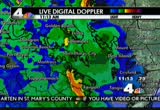
and as we look at the radar the last three hours we've had this continual flow in the atmosphere comingrom the south showing that tts beginning it is beginn off and the rains pulled north and east. there are still bands of moderate to heavy rains in southern maryland. thankfully as the afternoon progresses it does appear we will have some lighter rain amounts as we do get into the rest of the afternoon. and right now around the region as we take a look at the temperatures, it is right now in the mid-s for the most part from the blue ridge to the bay. we'll be holding steady for the rest of the afternoon. we do have a tornado watch in effect until 1:00. all these counties in yllow clude northern virginia, the district, montgomery, prince george's as well as charles, southern maryland, eastern shore. this tornado watch extends up and down the atlantic seaboard, too, between here and partsf pennsylvania and upstate new york as this storm system advances quickly off to the
11:39 am

north and east so our threat for sever weather will be greatly diminished as we get into the afternoon, late afternoon and evening hours when the rain will be ending and then tomorrow a big differce. we'll be having a blustery northwest wind. that will blow-dry things. we'll still have high water. many of the creeks and streams will take quit a while to recede so it may still have high water tomorrow even though the rain will have stopped. then over the weekend saturday and sunday partly cloudy, cooler, lows in the 40s. highs into the 60s. a weak front sunday giving us a small chance of a shower. some unsettled weather next week. there's some uncerinty about next week's forecast. sta tuned. we'll keep you posted as we get closer to the day. >> thank you very much,tom. two metro buses crashed with 40 people in all onboard the two. it happened at the intersection of university boulevard and burnett avenue in silver spring. nearly two dozen people had to be taken to the hospital. megan mcgrath has the latest on the accident thismoning. megan? >> reporter: well, barbara,
11:40 am
they've taken the two buses away but it happened in front of the bus stop on university boulevard. now exactly what happened is still under investigation. it's unclear whether one of the buses was stopped at the bus stop pickg people up or whether it was actually travel down university boulevd. the bottom line, though, is a bus that was hyped it in the same lane rear-ended that lead bus, the front of the second bus, crunched in the area where the driver was. the windshield was shattered and there were 20 people, 23 people actually that had to be taken to the hospital as a result of their injuries. now what we are told these are not life threatening injuries. they we transported. they are being treated but everybody is expected to is your vaf. >> all of them were nonlife threatening, most orthopedic type injuries, neck pain, back pain, some minor lacerations and abrasions. some more serious injurieswere injuries complaining of internal pain but obviously we can't
11:41 am

diagnose the field so we have to upgrade those and take them to a higher level of care. >> reporter: now the area where this happened is just down the street from blair high school and there were ten blair high school students on board these buses. eight of them were transported. again, not with anything that was considered to be life threatening but they are going to be treatedas area hospitals. the remaining two students, they were checked out here on the scene, they were okay. they were not complaining of any injuries and they were actually allowed to walk down the street and go to school for the day. again, in terms of what happened, all still under investigation. it's unclear whether or not weather was a factor in this. the rain has been coming down all day. we have a lot of water on the roadway but it's unclear whether or not that played a ctor. there was a lot of traffic in the area at the time. we're going to have to wait and see and make that determination later. barbara, back to you. thank you, megan. and we're going to check onhe
11:42 am

midday traffic right now. jerry edwards joins us with the latest. good morning. good morning, everyone as we check things out around the capal beltway. looks lick around connecticut avenue, what was there is no more, it appears nevertheless looat all the road spray. keep your speeds down. you can see by that branch smacking the camera the winds are beginning to pick up. let's update you making the trip to northeast. we did have the high water reported as you make the drive in through parts of northeast washington along rhode island avenue and over the american legion bridge. bevery, very cautious. we're seeing some ponding of water now in both the inner and outer loop particularly in the far right d far left lanes and traffic around the cleveland park metro station on connecticut avenue now blocked off because of that suspicious package. barbara? >> all right, jerry. you've had a busy morning. thank you very much. and we continue our series of reports on educati this morning. education nation. a weeklong focus by nbc news on the nation's school systems.
11:43 am

today we're joined by a lady who is on the front lines of the schools in washington, d.c. she's a teacher, andrea smith. good morning and welcome. >> thank you. >> we know you teach the sixth grade at e.l. haynes, a public charter school here in washington. why don't you tell us what the difference is between a public school and a charter school in the district? >> sure. the differences aren't as great as people may thin because we are a charter school we do have some flexibility in terms of how we structure our day and the length of the school year. we have an extended day program which makes our school day longer. >> year round so that makes a difference? >> the president was on track when he proposed making that switch overall in the public system as well. >> and speakinof the president, matt lauer interviewed the president on monday and asked him whether or not he thinks his chdren who are in school here, in ply vat
11:44 am

school in the nation's capital, could receive as good an education in our d.c. public school and the president answered no. what's your reaction to that? >> i respect the prident's right to choose where his children go to school. i think in d.c. that one thing we are doing well is providing parents with the oice. i think parents are going t vote with their feet so they're going to take their children to an effective school and i think our al is to make sure that any school public or charter is providing a quality education and that parents have the choice to take their students to those schools. >> now you are a very successful teacher, we're told. we've heard all about you. you're an epic spotlight teacher, an award winner for th that. you have improved the test scores of your student what's the secret of your success? >> a lot of hard work. i think it starts with really strong leadership at the school level. i have great leaders at my school who support me and who are invested in developing my
11:45 am

professional skills as a techer. it takes a lot of purposeful preparation, a lot of planning using the datahat you get from assessments drive your instruction and it takes extra hours. a lot of hard work. >> sixth graders are not easy sometimes, right? well, we are very happy to have had you come in, andrea smith. i'm sure that you will be example for many other teachers as they get to know how successful you've been in what you've done. we are grateful to have you. coming in the rain th morning. got to go back to school now? >> ye i do. >> say hello to your class, your students, and thanks again for coming in. >> thank you very much. and stillhead on news 4 midday the latest on our severe weather. hi there. i'm ian wright

11:47 am

and i'm investigating what makes aruba so happy. oh my word, that's fantastic. ♪ row your boat gently down the stream... ♪ i'll tell you what; it's not aloe vera the main export. it's happiness. i haven't even got baiton the e. i don't care; it's just nice sitting here. you're getti it. you're getting it.
11:48 am

"wednesday's child" is an outgoing young man who hopes his magic will make his dreams come true. he has moved from one home to another. he's hoping his appearance on "wednesday's chd" might help find that permanent home he's been waiting for. >> hi. >> hi. >> how areou. >> good. i'm excited. >> reporter: are you excited? i'm happy to be here with you at six flags. si flags is decked out in cobwebs for the october frightfest at a place for a show, we found ahost of spooky characters ready to greet us. are you scared yet?
11:49 am

>> no. >> reporter: we left the monsters hyped for the kinder face that was waiti for us. >> are you a magician? >> i am a magician. >> that's awesome. >> i heard that you would like to do some magic? >> yes. >> pretty hot book, isn't it? >> yes, it is. >> check it out. >> reporter: he could do a real magic trick he'd probably like to change some things about his life so far. >> like so many of our kids in virginia just didn't have parents that could provide him the love and support that he needed quite possibly because they didn't get the love and support they needed. >> are you ready? ♪ he is such a jovial kid. he's bright and funny. >> reporter: and he's resilient having spent so many years in foster care moving from home to home. how ny times have you moved? can you count? >> about 17 times. ♪
11:50 am

>> reporter: the six flags fright fest show featured some crazy characters and being a good sport j.d. jumped right in. do you think you'd like to be a dancer? actor? singer? >> yes. >> reporter: magician? >> yes. yes, yes, yes, yes. >> reporter: he would lake to invent video games some day like one wher a kid could create the perfectife and family. if you create add mom and dad for your game, tell me what they would be like. >> loving, cang. >> reporter: a magic tip and tickets to come back here were a nice surprise for j.d. but the biggesturprise is the crowd that wean to at the bumper cars. it capped off a day of laughter for a kid who deserves a little magic. so if you have room in your home and heart for j.d. or another child who is waiting, please call our special adoption hotline. the number 1-888-2-adopt-me.
11:51 am

and wek in the ne neroom right now to find out about some problem spots with the weather. elain that's ght, barbara. this is mostly taking place in northeast d.c. d.c. fire and rescue working on a few incidents that 1,000 block of rhode island avenue, a few people were stuck right there because of standing in the flooding water. they're working to rescue those folks. also in that same general area 1379 f street northeast, d.c. fire and rescue got called for a ceiling collapse. and finally in the 1800 block of capital avenue northeast at bethesda baptist church, some folks were stuck on the steps of that church. they couldn't get to their cars because, again, the standing water and the flooding water. they are very busy to help people make sure they can get to where they need to go in a safe manner. of course this has just happened within the last half hour. we'll continue to monitor the
11:52 am

situaon. again, most is happening in the northeast part of the district. >> elaine, thank you very much. 11:52 is the time you. coming up, a funay to enjoy pumpkin season andom kierein will be back with another check of the forecast.
11:53 am

equals chili's $20 dinner for two. share one of five appetizers, like our famous texas cheese fries. then choose two freshly prepared entrees from 14 chili's favorites, like our chicken crispers with new eet & smoky sauce, our new slow-smoked honey chipotle baby back ribs, or grilled all-white meat chicken fajitas served over a bed of sizzng peppers and onions. grab a friend and get one appetizer plus two entrees with chili's $20 dinner for two.

11:55 am

good morning, barbara. looking at the radar over the last three hours we've had the surmgs of heavy rain coming through that caused all this nasty flooding. it does appear we'll get a temporary respite. it's beginning to break out a little bit, just light rain across northern virginia but many locations to the east of washington still averaging moderate to heavy rai in southern maryland, rate along the western shores of the chesapeake bay. but there does appear to be a little bit of a dry period coming through here just maybe some ligh rain for a while this afternoon. however, we could get some more rain later on this evening. some more heavy downpours are possible for the region as we get into the evening hours but between now and then we'll have this rain tapering off so give a chance for many of these creeks and streams to run off but still with all of this rain that we have had, it is still going to take many, many hours for the creeks and streams to begin to recede and, unfortunately, it does appear we'll add some more rain to this later on tonight.
11:56 am
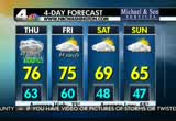
and then it will finally all end by dawn tomorrow. we'll finally get sunshine back on friday afternoon and get some blustery winds as well. temperatures climbing into the mid-7 by mid afternoon. then some oler weather moving in for the weekend, saturday and sunday. morning lows in the 40s. afternoon highs in the 60s. there is a small chance of a shower on sunday as a front does come through. then as we get into next week we could have more unsettled weather around the region and there is some uncertainty as to whether or not it's going to be dry or wet. just stay tuned. we will keep you posted. the latest now with the radar showing that we are beginning to see it tapering off now throughout much of the region and right at washington now we have just some light rain falling. when you see the blues and greens, light to moderate in. right now in northern montgomery county, some heavier downpours near annapolis still. certainly much of anne arundel county has taken the brunt as has calvert and st. mary's. they've had 6 to 8 inches since
11:57 am
midnight and through the morning hours and into the afternoon it should begin to taper off there a little bit as well, thankfully, as we'll see a little bit of a dry period cominin. as i mentioned, unfortunately, we may get some more rain later on tonight. maybe several more inches perhaps later tonight that may cause more flooding. jerry, how is our traffic? >> time to take a live look in northeast washington. this is the flooding. as peteold us earlier, some folks had to be rescued. it's a low-lying area of rhode island avenue traveling through ortheast. just an example. to the beltway in maryland, tractor-trailer accident on the inner loop near the 270 spur. fire and rescue crews have just been dispatched. be careful. plan accordingly. be aware conditions are still very, very difficult. barbara? >> thank you, jerry and tom. and that's nws 4 midday for today. we thank you for being with us and invite you to tune in at 4:00, 5:00, and 6:00 and then later tonight at 11:00.
11:58 am

i'll be back tomorrow morning with news 4 midday. hope you'll plan to join us. see you then. have a great day.
11:59 am

(vicki) previously on the real housewive business is more than i can handle, more than lauri and i can handle. so i need another mind behind building my agency.
586 Views
IN COLLECTIONS
WRC (NBC) Television Archive
  Television Archive News Search Service
Uploaded by TV Archive on
